About All-In-One Offline Maps
No advertisements ~ No data sharing & monetization ~ No analytics ~ No third party libraries Bored to wait for maps to display? Use All-In-One OfflineMaps! Once displayed, maps are stored and remain available, quickly,...
No advertisements ~ No data sharing & monetization ~ No analytics ~ No third party libraries
Bored to wait for maps to display? Use All-In-One OfflineMaps!
Once displayed, maps are stored and remain available, quickly, even with no network access .
•
Want more than just roads on your maps? You will find what you need here;
•
Used to go to places with poor network coverage? Everything will stay available;
•
Used to go abroad? You won’t be lost anymore;
•
Have a data allowance limit? It will reduce your usage.
★★
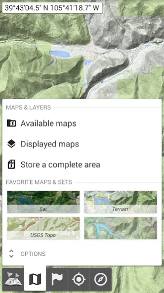
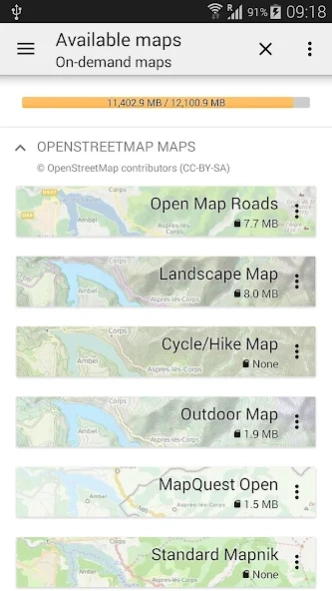
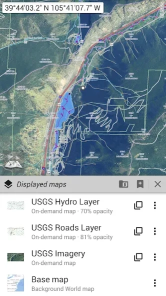
Maps ★★
A lot of maps are available, including classical road maps, topographic maps, aerial (satellite) maps and various layers that can be added over any maps: OpenStreetMap (Roads, Topo), USGS National Map (Hi-res topo, Aerial imagery), Worldwide Military Soviet topo maps, etc.
• All maps can be stacked in layers, with precise opacity control;
• Select and store large areas in few clicks;
• Stored space is clear and can be easily deleted.
★★
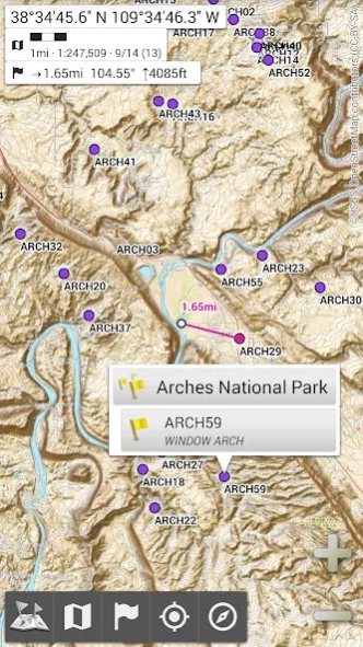
Display, store and retrieve unlimited placemarks ★★
You can add various items on the map such as waypoints, icons, routes, areas and tracks.
You can easily manage them using the powerful SD-Card Placemarks Explorer.
★★
On-map GPS Location & Orientation ★★
Your real location and direction are clearly displayed on the map, which can be rotated to match your real orientation (depends on device capabilities).
Easy turn on/off to save battery.
And also:
• Metric, imperial and hybrid distance units;
• GPS Latitude/Longitude and grid coordinate formats (UTM, MGRS, USNG, OSGB Grid, Irish Grid, Swiss Grid, Lambert Grids, DFCI Grid, QTH Maidenhead Locator System, …);
• Ability to import hundreds of coordinate formats from https://www.spatialreference.org;
• On-map grids display;
• Full screen map view;
• Multi-touch zoom;
• …
★★
Need more? ★★
If you are a real adventurer, try
AlpineQuest Off-Road Explorer , the complete outdoor solution based on All-In-One OfflineMaps, loaded with a powerful GPS Track Recorder and more: https://www.alpinequest.net/google-play
Previous Versions
Here you can find the changelog of All-In-One Offline Maps since it was posted on our website on 2019-10-25 11:00:19.
The latest version is 3.15 and it was updated on 2024-04-22 15:59:35. See below the changes in each version.
All-In-One Offline Maps version 3.14
Updated At: 2024-02-19
Changes: The complete list is available in the changelog inside the application.
3.14
• Added ability to set custom items in the map center point popup menu;
• Added new “Quick-routing” (quick auto-routing) that skips the creation dialog;
• When using the BRouter offline auto-routing service, a real-time preview of the computed route is displayed as the map is moved;
• And more
All-In-One Offline Maps version 3.15
Updated At: 2024-02-19
Changes: The complete list is available in the changelog inside the application.
3.15
• Added ability to display arrows, distances and ETE along the real-time location and compass heading lines;
• Added duration estimation of drawn paths and routes based on the selected activity, with time estimations of each route legs displayed on the map;
• Added new fields in the Explorer mode: North and target direction arrows;
• Added new imperial distance unit using meters instead of feet;
• And more
All-In-One Offline Maps version 3.13b
Updated At: 2023-10-26
Changes: The complete list is available in the changelog inside the application.
3.13
• Added ability to set custom fields in the top Explorer mode bar;
• Added new Explorer mode fields: instant slope and terrain slope (using 1″ stored elevation data);
• Added ability to measure distance and elevation gain between two points of a path;
• User is warned when he’s about to lose its current map configuration, and has the ability to save it as favorite before displaying a new map;
• And more
All-In-One Offline Maps version 3.12
Updated At: 2023-09-15
Changes: The complete list is available in the changelog inside the application.
3.12
• Added ability to specify a background color for dashed paths and tracks;
• Added ability to rename workspaces;
• Added mils based slope units;
• And more...
All-In-One Offline Maps version 3.11d
Updated At: 2023-06-10
Changes: The complete list is available in the changelog inside the application.
• In the auto-routing tool, long-pressing the “Delete” button now deletes the last segment entirely;
• Added ability to import multiple maps at once;
• Added ability to resize pictures when exporting KMZ files;
• The auto-routing tool now uses BRouter routings by default if available;
• And more...
All-In-One Offline Maps version 3.9b
Updated At: 2022-03-18
Changes: The complete list is available in the changelog inside the application.
All-In-One Offline Maps version
Updated At: 2021-11-29
Changes: The complete list is available in the changelog inside the application.
. Added audio waypoints allowing to record an audio track associated to a waypoint and play it from the map;
. Added global distance, time, elevation gain and area for displayed path, route and area lists in the placemark explorer;
. New Explorer mode fields: cell network strength, battery level, and GNSS constellations in use;
. Various improvements and bug fixes.
All-In-One Offline Maps version 3.6b
Updated At: 2021-01-27
Changes: . Improved print map tool (added display of scale bar, scale value and grid names);
. Improved display and input of location coordinate systems;
. Added a new setting to style the display of grids;
. And much more (check in-app changelog for more details).
All-In-One Offline Maps version 3.5c
Updated At: 2020-12-03
Changes: 3.5c:
. Added alphanumeric placemarks sorting;
. Improved opening of files from other applications;
. Improved KML/KMZ format placemarks import;
. Various improvements and bug fixes.
a/b:
. Added ability to add items to the clipboard (copied items doesn’t replace current clipboard content);
. Added ability to control maps and layers brightness and contrast separately;
. Added auto correction of GPS Week Number Rollover issue (reported date 20 years in the past);
. ...
All-In-One Offline Maps version 3.5b
Updated At: 2020-05-11
Changes: 3.5b:
. Improved search dialog (new “Clear text” and “Paste from clipboard” buttons);
. Added ability to make the compass point towards the grid north;
. Various improvements and bug fixes.
3.5a:
. Added ability to sort placemarks in reverse order;
. Added ability to add items to the clipboard (copied items doesn’t replace current clipboard content);
. Added auto correction of GPS Week Number Rollover issue;
. ...
Disclaimer
Official Google Play Link
We do not host All-In-One Offline Maps on our servers. We did not scan it for viruses, adware, spyware or other type of malware. This app is hosted by Google and passed their terms and conditions to be listed there. We recommend caution when installing it.
The Google Play link for All-In-One Offline Maps is provided to you by apps112.com without any warranties, representations or guarantees of any kind, so access it at your own risk.
If you have questions regarding this particular app contact the publisher directly. For questions about the functionalities of apps112.com contact us.